Concerning the closure of Cold Comfort Lane footbridge over the A435. This closes a key walking route into Alcester from the west and is a special issue to walkers along The Monarchs Way long distance footpath. The Monarchs Way team have published this walk around for walkers to from Alcester for the foreseeable future.
There’s lots of activity going on around The Exercise Yard at the moment. Routes being planned; refreshments packed and maps studied. This is the third walk in my Myton Marathon for the Myton Hospice. My plan was, and remains, to walk 26.2 miles around The Exercise Yard and I have a number of excellent sponsors supporting my efforts. In addition I have two brilliant walking companions, one of which, SHWF is pictured pretending hw knows what to do with a mobile friend.
So far I have completed two walks. Details can be found under the Walk tab on this site but basically, the first featured my headlong dive into a stream (5.55 miles) The second, a lovely and well-refreshed walk over the hill to Broom Junction and back along the old railway line. (6.61 miles). So we have a running (or walking total of 12.16 miles).
Today finds my walking companion and I taking refreshment at the Coronation Chairs out side Great Alne Village Hall. We are being well-behaved today so refreshments are limited to coffee. To be honest I’m not sure whether I should broach the subject of the hip flask with this companion. I’m not sure how it would go down.
The weather is chilly and blustery with a crystal blue sky but with a threat of rain squalls. We have experienced a squall walking over the fields between the Alcester Trig point and here. Not too bad, we are suitably attired and were able to dive under some trees. So now we are about three miles into our planned walk and discussing the next stage when..
“Is that your phone or mine?” Hands plunge into bags and pockets. “Er mine”, says walking companion. “Its my son, I’d better take it.” I smile assent. The upshot is daughter in law has trapped her thumb in the car door and can my companion step in and look after the kids during the visit to A&E. After some discussion we decide on the best short cut so companion can grab the car and go.
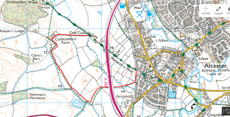
The first part of the walk follows the railway track bed of the line between Great Alne and Alcester. The Stratford Upon Avon Railway opened the line between Alcester and Bearley in 1860 but it was never more than a rural branch line. Great Alne station closed in 1944 and the line itself struggled on until 1951.
After a few hundred yards the track bed opened out onto fields and we struck off across them towards Kinwarton Dovecote. The followed the lane to the Alcester – Great Alne road. After which we strode as quickly as possible towards Alcester before parting company in the town centre.
The Kinwarton Dovecote
Happily an X-Ray revealed only bruising to daughter in law’s thumb so no harm done there. The walking distance for this was 6.11 miles bringing the walked distance up to 18.27 miles which is great.
If you have been inspired to take this walk, we used OS Explorer 205 and I have placed some adapted guidance in the Walks tab.
Walkers on the Monarchs Way west of Alcester will find that the footbridge on Coldcomfort Lane / Allimore Lane is closed, apparently for the foreseeable future. Apparently some delightful characters have taken it upon themselves to steal part of the metal guardrails thus making the bridge dangerous.
Broom Junction Station courtesy Warwickshirerailways.com
Regular readers of this blog will note a recurring theme, railways. Today’s walk was chosen for two key reasons. 1. There are no fords to fall in. 2. We get to walk along an old track bed. By the way, many thanks to Warwickshire Railways for the photo of Broom Junction in its pomp.
Today I was walking on behalf of Myton Marathon with my silver haired walking friend. This is the second walk towards my 26.2 mile target. The first, a soggy 5.55 mile contribution. SHWF and I have walked this route several times so today I m confident. What could possibly go wrong?
It is a stunningly beautiful, if chilly day. The sky is a clear, crystal blue. Perfect for our walk. The chat begins as we stroll up the lane towards the footbridge and then the track towards Oversley Castle and one of my favourite viewpoints around Alcester. The vista sweeps from the Malverns in the west to the Cotswold escarpment in the south and ranges over the Vale of Evesham.
Big Sky. The view from Oversley Castle
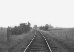
From here the path winds down to the timbered village of Wixford and our first refreshment stop. Sadly, The Fish Inn is closed at the moment so weborrowed a table for our repast of Mrs SHWF’s Christmas cake and some fortified coffee. Delicious!
Much cheered, we continued along the Heart of England Way towards Broom. First through a small wood past a delightful waterfall and thence crossing several fields abounding with tiny leaping lambs and their watchful mothers. This section of the walk is not long, just far enough to raise a thirst.
Suitably refreshed again, SHWF and I proceed over the River Arrow and turn take the path back towards Wixford. Beyond the remains of the station the route drops onto the old track bed for short stretch (circa 1.5m) alongside the River. At Wixford the path drops down a steepish embankment at Wixford station where crumbling remains of the platform are still visible.
The Redditch Railway built the line between Barnt Green and Aschurch during the 1860s. It provided worthwhile service to the villages along its route and a valuable bypass to the infamous Lickey Incline. The line, known as the Gloucester Loop was adopted by LMS in 1923 and finally closed by BR in June 1963 leaving only the section between Barnt Green and Redditch.
But back to the walk. We have now passed under the A46 and are approaching Arrow where we are forced off the line, through a gate. Thence through a convoluted array of gates, bridges and embankments we emerge in Alcester and the end of our walk. The sun still shining, it was time to investigate the contents of my fridge for a beer.
Broom Junction has contributed 6.61 miles towards my 26.2 mile target which, added to my 5.55 miles already walked gives me a total of 12.16 miles.
Our walk can be followed in OS Explorer 205. I have placed instructions starting from St Nicholas’ Church in Alcester in the Walks tab
I am sitting in The Spittle Brook. Water is trickling down my face. I am picking bits of weed from my hair and the brook undeterred by my presence continues to flow over me. My companion is biting her lip, her face reddening as she desperately, and quite successfully, tries to stifle the laughter she must be feeling. A totally random lady dog-walker appears full of concern and empathy. “Are you all right dear?” she asks, keeping a straight face.
It had all begun so well. My walking companion had been keen to get involved and mentioned that a footpath passed behind her house but she had no idea where it went. I checked my OS App and the first Myton Marathon walk was born.
The day had dawned grey but dry as we followed the path behind her house, following the path of the old railway line. Then through a new housing development and over the by pass. We were now in the countryside walking through stubbled fields. Chatting happily we picked our way around the soggy bits heading for Alcester Heath.
We skirted the rear of Alcester Lodge, walking along the field edge down towards the ford. I helpfully pointed out some Victorian archeology half-hidden in the copse as we approached the stream. My companion tripped elegantly over a couple of impromptu stepping stones and I followed. Skidded, slipped, toppled, groped the air and collapsed headlong into the icy waters.
Having extricated myself from the brook and drained some of the excess stream from my shoes and trousers. I gathered what remained of my tattered ego and we resumed our walk. At the point where The Millennium Way swings towards New End we turned up the bank until meeting The Monarch’s Way heading towards Alcester. We now followed this path for the rest of our walk (splash) through Coldcomfort Wood over the by pass and back into town. Whereupon I took my leave of my companion and squelched homeward.
Despite all we managed 5.55 miles of my 26.2 mile target which in the circumstances is pretty good and I was left with little more than cuts, bruises and a nasty case of Nappy Rash!
For those who wish to try this walk I will place some guidance in the Walks Tab
Spring is approaching, release from lockdown is at least a possibility and so its time to start some serious walking. So, when I received an invitation to take part in The Myton Marathon on behalf of The Myton Hospices it seemed an excellent opportunity to get a bit fitter and raise some funds for an excellent organisation who were incredibly kind to Margaret and me during her last hours. So I will be walking in excess of 26 miles during March and I’m looking for your help.
Here is the link to my Just Giving Page. I will be blogging about my progress during the month here and I’m hoping you will be good enough to make a small contribution to a really excellent cause. Thanks very much
To say I was not too enthusiastic about a walk today would be an understatement. The weather was grey and trees were waving and bending in a cold and uninviting manner. I turned up the heating a notch and settled lower in my site nursing my second cup of tea, at which point the guilt set in. “You can’t sit here all day watching TV.” I self-scolded. “Now, get dressed and get out there. It’s only an hour and a half.” I self-negotiated a final cup of tea and stumped off, grumbling, to comply.
So, I am just about to leave when a particularly sharp blast of wind hurls a spatter of sleet at the window. But too late now. I have donned many layers and waterproofs so I sallied forth. It’s Sunday so the plan today is simply to walk the Town Circular which is an infinitely adaptable circular walk around town. Today I have two changes planned. Firstly, to walk through the nature park, a preferable diversion now it dryer underfoot. Secondly to divert down the town high street for reasons which will become apparent.
The walk is going quite well for about 100 yards when, rounding a corner I am hit in the face with a blast of icy wind and sleet with origins in The Ural Mountains such was its ferocity. However the walk through the nature park, while cold was, at least, dry and firm and the weather hadn’t dimmed the wildlife activities as I walked by.
Now we come to the multi-tasking bit. It is an easy diversion into the High Street by the church. This is where two shops are situated. One, the paper shop and the second, a cafe offering takeaway food on a Sunday morning. And this is where the clever bit comes in. I approached the cafe, ordered and paid for a bacon and egg sandwich and then, while awaiting its delivery, crossed the road to collect my paper. Thus, and this is the really clever bit, allowing me to re-cross the road to collect my sandwich. How about that?. Walk, breakfast and paper all at once.
The rain woke me last night. The hammering on the roof eventually forced me from my bed to make a cup of tea before retiring again to my new book.
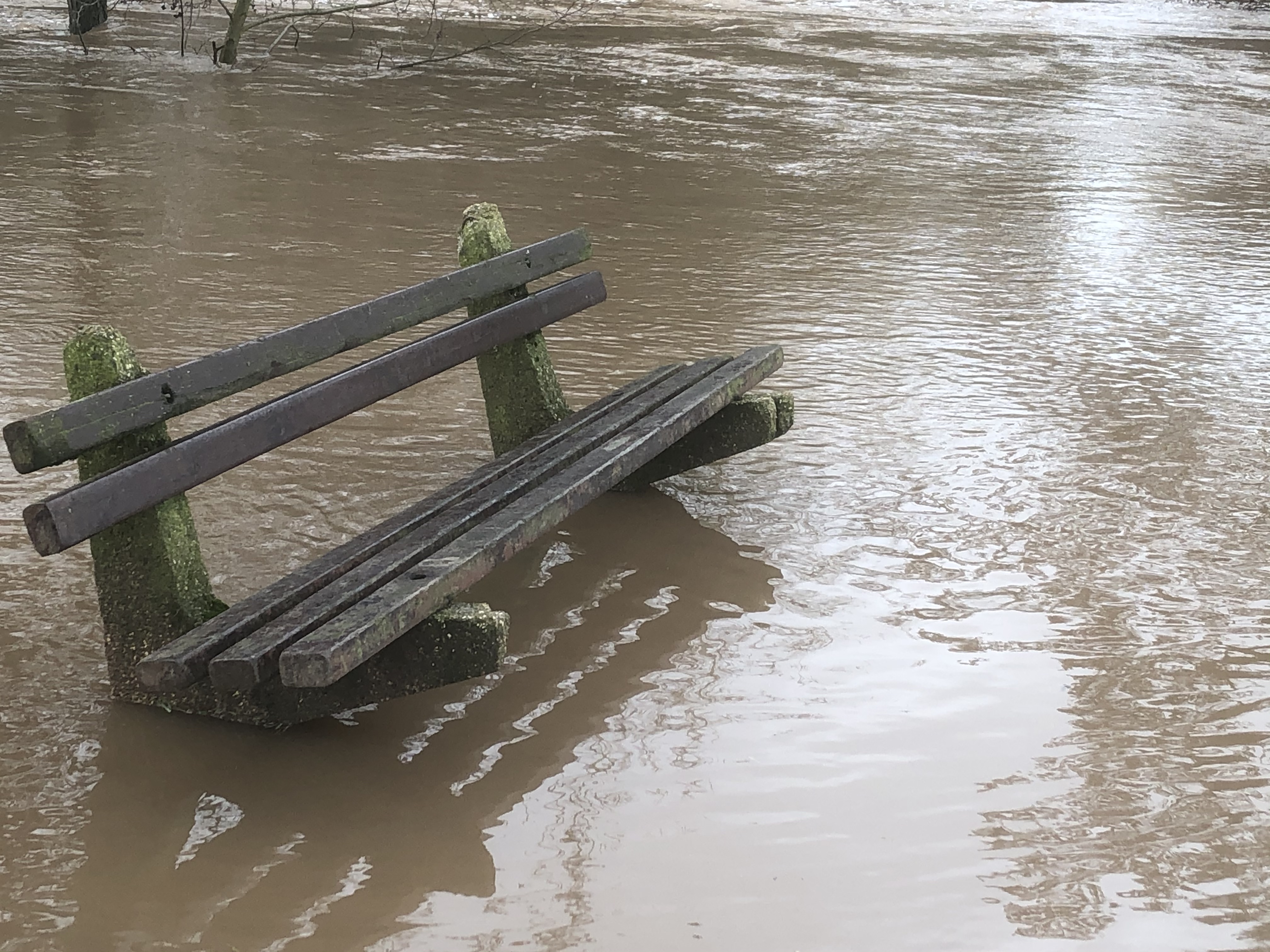
Later on I surveyed the Exercise Yard to see river water flooding in from all corners but it had finally stopped raining for I decided to sally forth to check out the usual weak points in the defences.
Crossing the river at the old railway bridge I turned into Conway Fields. The river had broken it’s banks in a number of places and lay across the footpath daring the unwary and foolhardy. I am, however, made of sterner stuff and I was wearing my new non-leaky boots but even so it was impossible to negotiate the flooded path at the Sports Centre end.
I spent some time leaning on the parapet of the 17th century road bridge,. The river is squeezed between a concrete straight jacket here and it roars swirling, surging, a dark, turgid brown with the occasional plastic bag or bottle careering onward spinning and pirouetting frantically.
When next I meet the river it had been squeezed around the town centre and further swollen by it’s convergence with the River Alne. Now released from it’s concrete confines it spread over a wide flood plain. On the far side a small group of muddy cows observed its progress suspiciously, obviously as though offended by the loss of their lunch.
Closer to home now, the river sweeps right in a huge arc and the flood plain moves to the inside of the curve. Through the bridge and Oversley Green sits on higher ground. The flood water now sweeps across the fields back towards Alcester. I check out the footpath from town to Oversley to find it completely impassable. An allotment holder leaning on the gate tells me the water is still rising. A hopeful runner turns up hoping to get through. Not today I’m afraid.